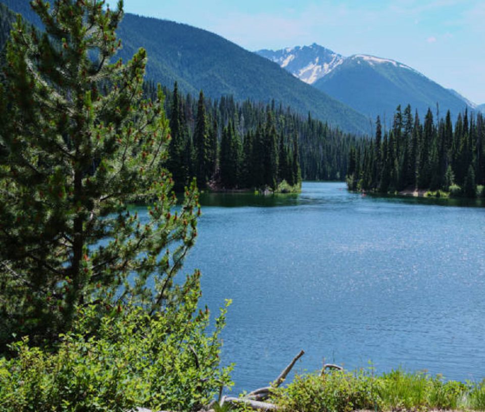
E. C. Manning Provincial Park also called Manning Park is a provincial park in British Columbia, Canada. The park is situated within the province of British Columbia, in the southern part of the country, 3,400 km west of Ottawa and 1,261 meters above sea level. The park is a category II protected area (nature park).
Manning Park: 8 Facts About The British Columbia Park
1. E.C. Manning Park is located in a valley:
The land around E.C. Manning Park is hilly to the north, but to the south it is mountainous. The highest point in the vicinity has an elevation of 1,805 meters and is 1.6 km northeast of E.C. Manning Park. The area around E.C. is almost covered with dense deciduous forest.
2. Manning Park is isolated:
There are less than 2 people per square mile around E.C. Manning Park.
3. The climate is subarctic:
The average temperature is 1 ° C. The warmest month is August, at 14 ° C, and the coldest January, at −10 ° C. The average rainfall is 849 millimeters per year. The wettest month is March, with 113 millimeters of rain, and the wettest August, with 29 millimeters.
4. Geography and borders:
The 708.44 km2 park is located in southern British Columbia, on the border with Washington, United States. The park is located in both the Fraser Valley and Okanagan-Similkameen regional districts.
The park shares its boundaries with several other protected areas, namely Skagit Valley Provincial Park and Cascade Recreation Area in British Columbia. In Washington State, it shares its boundaries with Okanogan National Forest and Ross Lake National Recreation Area. The park is located at the northern terminus of the Pacific Crest Trail.
Manning Provincial Park extends directly north of the Washington State border and forms together with North Cascades National Park, Ross Lake National Recreation Area, Lake Chelan National Recreation Area, Cascade Provincial Recreation Area, Skagit Valley Provincial Park, and Chilliwack Lake Provincial Park is a closed sanctuary in the north of the Cascade Mountains.
The area of the park includes the headwaters of the Similkameen River and Skagit River. The Crowsnest Highway (BC Highway 3) crosses the park through the valleys of the Sumallo River, the Skagit River and the Similkameen and overcomes the highest point in the Cascade Range at Allison Pass (1,341 m). A paved back road leads to the Lightning Lake Campground, unpaved back roads lead to a parking lot near the Shadow Fall (Gibson Pass Road) and to Blackwall Peak (2063 m – Blackwall Peak Road).
5. The name of the park:
The first protected area in the area of what is now E.C. Manning Provincial Park, was named after Ernest C. Manning, the head of the forest administration of the province of British Columbia between 1936 and 1941, was the Three Brothers Preserve, on which 6,440 hectares protected the flora of the mountain meadows in what is now the northeast of the park.
He died in a plane crash in February 19411.
6. History:
The area of the protected area was doubled in1936 and the Three Brothers Wildlife Reserve was established.
The provincial park was established in 1941, and the completion of the Crowsnest Highway between Princeton and Hope in 1949 made the park popular as a recreational area for the Vancouver metropolitan area. After a change in October 1999, the area of the park was last expanded to its present size in May 2012.
7. Activities:
Due to its easy accessibility from Greater Vancouver and the Okanagan Valley, Manning Park is also of great importance as a recreation area, which is also reflected in the tourist infrastructure.
At this park you can find four campsites.
All four are located in the corridor created by the Crowsnest Highway, the Manning Park Lodge is located on the north bank of the Similkameen River about 6 kilometers east of the Allison Pass near the access to the Shadow Falls and Blackwell Peak.
8. Rare flora and fauna:
British Columbia’s ecosystem is divided into different biogeoclimatic zones. Biogeoclimatic zones are characterized by a fundamentally identical or very similar climate and the same or very similar biological and geological conditions. This occurrence results in a very similar population of animals and plants in the respective zones.
Within this system, the park area is assigned to different zones and subzones.
The park area includes numerous different biotopes, 63 species of mammals and 206 species of birds are native to it.
In addition to the species typical of the biotopes, the park is home to some rare animal species. The populations of the badger, the stubby-tailed squirrel, the gold-coated ground squirrel and the wolverine are important, and the park is also important for the reintroduction of the grizzly bear in the northern Cascade Mountains area.
The park has significant stocks of the spotted owl, which is considered threatened in British Columbia, and a conservation program is in place in the park area.
The occurrence of Rhododendron macrophyllum in the rhododendron flats is considered one of the northernmost of its kind, this plant species is one of only three protected plants in British Columbia.